
San Pedro de Atacama
En-route to San Pedro de Atacama
[Sally 6.4.16] We arrive in San Pedro de Atacama at lunch time after an easy ride from Calama, through some more of the Atacama desert opening up to mountainous scenery. We book the tours we want to go on tomorrow and need to get an early wine-free night as we have to be up at 4am for the first tour. So we decide to use the hotel 'restaurant' and have a simple early dinner. There's no menu - we can have chicken or hot dogs. We choose hot dogs. Now, I have a vision of a great hot dog with some great freshly made dressings, but I know to lower my expectations and expect just a hotdog in a bun. We are the only people in the restaurant, but the hotdog prep still takes about 10 minutes. When it arrives I'm a bit stunned when I look down at my plate - how low do I have to lower my expectations? There are 2 hotdog sausages on a plate - full stop. Good job we ordered a side of fries between us to turn it into a gourmet meal.
Next day, we're up and waiting for our tour bus pickup at 4:30am to see the natural wonder of the Geysers del Tatio. We're at the geysers before the sun rises, and it's really cold - but they are worth it - with steaming and bubbling geysers, and hot streams. On the way back we stop at a tiny indigenous village. We're not allowed to photograph the people, but there is a church at the end of their street.


The Milky Way
We get back to San Pedro after lunch and have an afternoon nap as our next tour is late at night from 10:30pm to 2am for star gazing in the desert. Jeff has a go at photographing the night sky.
San Pedro is a quite a small, remote town in the desert, and has built up a tourist industry for itself with lots of restaurants and various types of accommodation. Still, the town is quite pretty in places, regardless of all the tourist trappers.


Time to leave San Pedro. We're heading for the Bolivian border but it's too far for us to do in one day, so we head back to Calama for one night and choose a nice hotel on the outskirts of town. It's not all plain sailing though as Google Maps and Navmii have the location of the hotel wrong and we go around in circles for a bit before we stop in a shop and ask.
Next day we head for the Chile / Bolivia border town of Ollague. We know some of it is dirt road and as usual I'm nervous in the morning - but at least it's Chilean dirt road which we've come to trust and know it's usually in reasonably good condition. There are some stunning mountains along the way - some with fabulous colours on their crest, and I later learn the colours are from previous volcanic eruptions - throwing out different minerals. About half of the road is paved and half a decent hard packed dirt road.


Paved road takes us to the edge of Ollague town, then its all dirt roads. 'Town' is tiny but we haven't been able to book anywhere, we just know of one hostel through the iOverlander App. We find the hostel without too much trouble but they don't have any vacancies. Oh no! A woman gesticulates with her arm while talking rapid fire Spanish and we understand there's another hostel around the corner on the next road. We end up passing the police station, some lockup cells and entering some railway sidings. Hmmmm, this doesn't look right. The town is small but it's split in two by a freight train station with a long freight train on it and it's not easy to ride around. Jeff goes and checks out the railway sidings while I go to the police station. It's locked, I ring the door bell and a policeman comes to the door and invites me into a side office. "Sit down on this nice leather sofa here" he indicates. How nice. I ask where there is a hostel. They try to explain where it is but can see a bit of a glazed look on my face. He suddenly picks up his car keys and 'says' follow me. He escorts us through town stopping at three hostels - he goes in and asks for us - we finally get lucky with the 3rd and final hostel - phew, I didn't fancy having to camp here, although my plan B would be to ask if we could sleep in the police cells.
Police escort to find a room for the night!
This is the main road through Ollague with our hostel just on the right, and our bikes parked at the back.


The next day I'm really nervous as we are crossing into Bolivia, which is the poorest country in South America, and I'm worried about the state of the roads. We have 230kms to ride to Uyuni and we know a lot of it is dirt road. How bad can it be? We get through the Chile border quite swiftly, ride through no man's land for a short distance and arrive at Bolivian border post:
Bolivian Border post at Ollague
We're lucky with our timing as they close for a siesta from 12:30 - 14:30 and just make the processing of customs and immigration just before 12:30. We both need the loo, but they don't have one. Really? You're miles from anywhere. They indicate we have to go bush. I'm not doing that anywhere near these buildings, so we just have to get back on our bikes and carry on until we find a spot in the desert where we can go. The road out, Route 701, is a dirt road as expected and I'm leading at a steady 55kph, assessing the road and seeing if we can trust it. It doesn't seem too bad at all - quite hard packed and not too difficult to ride. We've ridden about 4kms from the border and I'm starting to build up some trust in the road, but still doing 55kph, not fully trusting it yet. "Trust no-one", my Dad used to say. I reach a small crest and just over the top of it I see one of motorbiker's biggest nemeses - a deep pit filled with sand. It's too late to avert it, so I stand on the pegs and hope for the best. The front wheel digs deep, throws a left wobble, I think I might have caught it but it throws a sharp right and down I go.

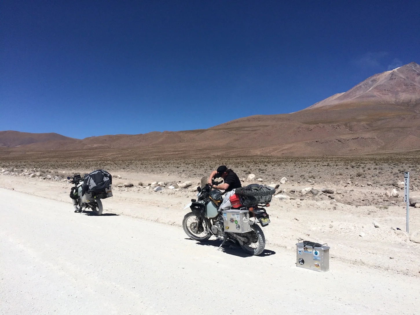
I'm mostly OK but my right foot hurts. I won't take my boot off - better to leave it on if we've got another 224kms to do. Bike damage? The right pannier pops off as designed to minimise damage. The right bark buster has shifted around but it's done it's job and saved the brake lever. There's no other obvious damage. Jeff gets to it and re-fits the bark buster for me while I take a rest and see if I can wiggle my toes. I can, and nothing seems broken, but I'm sure they'll be swelling and bruising to come. Suitably recovered and bike fixed, we set off again, with Jeff on sand lookout duty up front. At least we know we can't trust the road and go a bit slower. We're on the fringes of the Atacama Desert, and the scenery is quite interesting with mountain ranges and the odd llama.


We stop on a "side road' which looks a bit sandy but we take it steady and have a bikkie break.


I was hoping that by the time we join RN5 the road would be paved, but NO. The road deteriorates as the population increases with villages then small towns popping up. There are some roadworks with a diversion. We're always apprehensive of those as the diversion road is usually a lot worse. Jeff's in front about 300m and the diversion is a sharp left and he manages OK but doesn't get a chance to warn me. When I get there I see I'm headed for another deep patch of sand, again too late to divert, and down I go again - but thankfully it's a soft landing this time. There's a car and a minibus behind which I'm blocking. The man in the car gets out and helps me pick up the bike and push it to a flatter bit of sand. I catch up to Jeff and we crawl along this sandy diversion and are really thankful when we get back to the shoddy dirt road.
The light is starting to fade and we’re riding in twilight when we hit the outskirts of Uyuni, the sun blinding my vision just to help things along a bit. Thankfully we reach our hostel just as it the sun goes down.
Uyuni
Trip Advisor’s number one restaurant in town is a pizza place run by an American and his Bolivian wife. Google maps has us walking right up to the entrance to a military base in town. A gun-toting soldier on guard approaches us, and, in what must have sounded like a primeval grunt, I utter in pigeon Spanish “WHEEEERE PIZZZZZZAAAA”. But thankfully he doesn't shoot me for my appalling Spanish. Just waves us around the block. I'm hobbling from my stack in the sand and I'm half hoping he will let us walk through the base, but you know where hope gets you. "Hope is a dangerous thing. Hope can drive a man insane". So I hobble around the block, but the pizza is worth all of the effort of riding and hobbling today. It is the best pizza I have ever had..... really. If ever you're in Uyuni go for a pizza at Minuteman Revolutionary Pizza - through a hotel, just by the military base!
The next day we spend getting information on the Salar de Uyuni - the salt flat. Finding out how to get onto it and how to find Isla Incahuasi.
Salar de Uyuni
Salar de Uyuni is the largest salt flat in the world, covering 10,582 square kilometres, and is estimated to contain 10 billion tonnes of salt. The significance to us of this salt flat is expressed on our website home page - that is a photo of Isla Incahuasi on this salt flat.
Of course, I'm nervous again this morning. I've seen YouTube clips of a dirt road getting onto the salt flat. Scared of the enormity of the Salt Flat and getting lost. Scared of camping in the cold. Scared of running out of water. Scared of the state of route 30 up there. Scaredy cat - Poop city.
To begin with, getting out of town is a challenge and the reasonably nice town centre soon plummets into slum with dirt "roads". Thankfully I didn't get chance to add that to the scared list this morning! We get out without too much trouble and we're on our way. It's only 25km to Colchani where the turn off is for the salt flat. Colchani is a depressing looking salt mining hamlet. The road down to the salt flat is surprisingly OK and within 5kms we're on the salt.
We’re heading for Isla Incahuasi - an island 70km into the middle of the salt flat. There are several rough “tracks” made by regular 4x4 tours, but there are several islands in the salt flat so Jeff navigates by GPS coordinates only and we ride on virgin salt. It’s an amazing and very surreal place.
We see the island approaching, but you’re perspective is shot as there are no reference points, and we ride towards it for ages - maybe for 30 minutes or so. The island is covered in large cacti hundreds of years old. And the bikes are covered in salt. For tourism they have built some amenities on the island - toilets, shop, cafe, museum. It’s really busy with tours and personal drivers. We have a set lunch in the cafe before doing a recky around the island for a good camping spot. We decide on a spot on the SW side so we can see the sun set.
One traditional thing that has to be done on the salt flat is a perspective photo.
Jeff holding my bike in the palm of his hand.
I collect some salt from the ground to use in cooking pasta later on:
The sunset is pretty nice, but with it goes any warmth there was and the temperature plummets. I get cooking pasta fast so we can eat and go to bed and get warm.


Jeff takes some lovely night shots.
Night time on the salt flat.
I'm not too cold in the tent in my thermal long johns, warm trousers on top, thick thermal socks, 2 merino wool T-shirts and my fleece - into inner silk liner sheet with a hood and then into my sleeping bag, also with a hood. Not forgetting the comfort of my duck down pillow and tempur pillow. It's cold by morning though - just before sunrise it's about 1°C. Of course you need the loo first thing - well at least it makes us get up early to see a bit of the sunrise. And of course, we're in the shadow of the island so we're freezing, so we take a walk into the sunshine.


We just have a quick breakfast of a coffee, a banana and slice of cake we took as a doggie bag from the buffet breakfast yesterday. It'll do until we get off the salt flat. Here's just under 3 minutes of riding with us on the Uyuni Salt Flat, Bolivia.
I'm nervous again this morning as we don't know what the rest of route 30 is like. The last reports we heard from October last year were of road works, but it's better than the alternative of exiting the salt flat to the north into some quite rough road around a volcano and possible sand. So we decide to exit through Colchani, the way we came in. We were hoping to get some lunch from there, but the whole place looks a bit dodgy, desperate and no obvious signs of a cafe so we ride on and hit route 30 northbound. It turns out to be a really great road and a motorbikers dream of newly paved, gently sweeping curves, surrounded at a distance with mountains. We pass many fields of crops of quinoa, which apparently only grows above 2000m (so says wiki).
On a personal note, my face is a mess! I think it's a combination of dry desert air for the past 2-3 weeks, high altitude for a week or so now, and to add to the general mess, my face got sand blasted with salt spray yesterday, and now I've got big angry red patches on my face - very attractive.
We're hungry and we turn off down a little rough dirt road into a small village en-route, but it seems like a ghost town, and is as ugly as Colchani. There's no-one around, and nothing that looks like a cafe or even a little shop. Back on the road again. It's another 60kms and the road passes through a town called Rio Mulatos where we stop for a set lunch in a cafe. Just outside is the height of Bolivian railway.
We're heading for Challapata, just a half way point. We arrive about 5pm and manage to get a room at hostel listed in the iOverlander app. Double room to ourselves, but shared bathroom. The water is just about luke warm and the taps give little electric shocks to keep you on your toes and stop trying to get hot water. We go to the street corner for dinner and there's a choice of rice or potatoes to go with tonight's spit roasted chicken. It's actually really good - the chicken is spit roasted over coals in a black 'oven' just outside the door.
Orura
After a pretty lame breakfast at the hostel, we head for Orura today - just a short distance. We've nothing booked, but decide to get fuel when we first arrive in town. Hmmm, if only it was as easy as going to the first petrol station we come to. We kept getting waved onwards to another petrol station. Fuel is subsidised by the government for Bolivian nationals only; throughout Bolivia. Foreigners have to pay between 2 and 3 times the pump price. This is strictly enforced, there are cameras and often security guards ensuring the pump attendants follow the procedure. However, some petrol stations aren’t geared up with the right paper work or don't know how much to charge to be able to serve you. We got lucky on the 6th petrol station we tried. Orura is quite a big town/city, so we park near the train station so we can search for lunch, then accommodation. We stumble across a good lunch time restaurant with a set menu of soup and a main dish. The owner is very helpful and recommends 2 hotels - one 3-star, the other 5-star. He phones the 5 star for us and says it's BOB1380 - and we miscalculate it to A$70 thinking - wow that’s ok - let’s have a bit of luxury for one night after a few rough nights. We go and realise it’s not quite that cheap - but we’re looking forward to it already to get a decent hot shower and get scrubbed up - so we splash out for one night. From what we’ve seen of Bolivia and the outskirts of this town - we don’t really want to try for a lesser standard. From what I’ve seen of Bolivia so far, the South, - it’s quite depressing. The small villages we’ve seen, those we passed through, and those we can see from the road - the whole place looks dilapidated - small dwellings made of mud coloured brick, some half built, some in ruins, no road infrastructure - just muddy tracks.
The hotel is very nice; it's warm, it has hot water and the taps don't give you electric shocks.
La Paz
Next day is a long day of riding for us - 360kms to Copacabana. We decided a while ago that La Paz was a city we could quite happily live the rest of our lives without ever seeing. So we're planning a route that skirts the outside of the city. It looks like it might be a ring road. Our navigator estimates 5.5 hours of riding; we ride out at 10am, leaving us 3 hours buffer before sunset.
Road side cafe.
My bike's not very well today it's suffering from the high altitude and maybe the fuel we filled up with yesterday. It's struggling to get to 80kph and loses power going up any incline - of which there are many. But at least a lot of this road is dual carriage way so cars can overtake easily. We stop for lunch in a small town we pass through. We take a set menu lunch at this "road side cafe". That's about 45 minutes of buffer gone. We both need the loo so I ask where they are. They say they haven't got any - "maybe over there", "or over there", "or down the road a bit". Who knows, but they started laughing, so we left and hoped to find a petrol station down the road quite soon. We did about 40kms away.
Approaching the outskirts of La Paz was very busy, dirty from exhaust fumes and the urban sprawl started early. We got caught in heavy traffic down bus/taxi lanes, but managed to escape a bit further along. I'm leading and navigating, and we're coming up to a turn off onto the "ring road" bit, but the navigator instruction is not clear and I miss our turn off. There's no where to turn around and we've now been slung shot onto a long winding decline, getting sucked into the black hole of La Paz. And what a hole it is. We get caught in ridiculous, aggressive traffic - with buses and taxis cutting us up and spewing filth out of their exhausts. Our navigator seems very confused and leads us around the city through vehicle and human soup. There are road junctions without traffic lights and it's every man for himself - causing grid locks until a some traffic lights further down pop a cork and a few cars can move. My navigator finally directs us out of the main bedlam, up some side streets - but the streets are so steep my bike struggles like crazy - I'm in first gear, slipping the clutch and it's nearly dying. I'm only saved by another wrong turn and we end up in a cul-de-sac on a hill with a 60% gradient. I manage to stop OK, but Jeff's bike slides back a bit - his brakes not holding at first. We stop and take a breather. We can't work out quite where we are, but it doesn't look a good prospect to carry on going up. We get our bearings from a woman passing by, and she confirms going further up the hill will take us near the "ring road". I can't risk it - I don't think my bike will make it up such a steep hill at this altitude. I suggest we go back down into bedlam and find where we can join the road we came in on - which is along winding road back up. We stand a better chance of my bike making it. So back into the crazy traffic again; we're stuck behind a car chucking out loads of smoke and we can't escape it - I think I might die here, coughing and spluttering car fumes. We make it to the start of the long winding road back up, take a breather at the top and are quite relieved to think we'll be on the "ring road" just after the toll booth. We've lost all of our buffer time and it looks like the last bit of riding will be in the dark, but we're hoping at least to make it to the ferry before dark as that has its own challenges.
Our relief is short lived. Finding the turn off is a challenge as there's lot of cars, buses and people milling around the turn off. People pushing carts from the market. We do make the turn off all right, but it's far removed from a ring road - the urban sprawl continues with more traffic, taxi lanes, people. But we're patient, at least we're going in the right direction, for now. The navigator instructs bear right and we end up on some rough road, then back streets, then to our "road" - which they haven't finished building yet. After a bit if trial and error, we decide to follow the traffic outbound and are finally led to our road we want to be on. Still the urban sprawl continues with erratic driving and lots of road work diversions. Eventually it all thins out and I think we're finally out of La Paz - what a nightmare - it's cost us about 2 hours getting lost in there. My nephew, James, mentioned you could have unofficial tours of the prison in La Paz - I think we just did our own tour of the prison that is La Paz - and we got out!!!!
The sun is setting and we've got about 1.5 hours to go to the ferry. We don't know what time it runs until - but we'll cross that bridge when we come to it. Hopefully there's accommodation at the ferry town if we need it. This the first time in South America we are riding in the dark, and I'm getting flashed by nearly every car passing me. Perhaps those HID lights Jeff fitted are a bit bright! Jeff suggests getting a room this side of the ferry if we can. I'm a bit suspicious - that's not like him. Is there something he's not telling me about the ferry? We reach the ferry and before we have time to decide what to do we're being called forward to ride onto said "ferry". It's a bit of a stretch of the imagination to call it a ferry. It's a raft with uneven planks, gaping holes and short sides. We ride on behind 2 cars and the surface is so uneven we can't get off the bikes. It's only a short crossing but the barge is rocking a bit and we have to concentrate to keep the bikes up right. Jeff tells me later he's heard of bikers dropping their bikes through the holes on the barge and having difficulty getting them out again. This is what we cross the Strait of Tiquina on:
The "ferries" across the Strait of Tiquina
These aren't roll-on roll-off barges either, we have to push the bikes off backwards at the other side.
We've got another 40kms to Copacabana and we know the road is winding up and down over a hill, but we don't know if it's paved or not. We find out first, as we can do without a final challenge of the day riding in the dark on winding, dirt roads. It's confirmed it's paved so we decide to make a last push. The road is quite nice and I'm sure it must have fantastic views over Lake Titicaca, but we can't see. We arrive in Copacabana after 11 hours of riding, singing along to Barry Manilow "At the copa (co) Copacabana (Copacabana)".
Copacabana
Copacabana is on the shores of Lake Titicaca, which is thought to be the birthplace of the Incas. It is a large, deep lake in the Andes on the border of Peru and Bolivia; is the largest lake in South America by volume; and is the highest navigable lake by large boats in the world, with a surface elevation of 3,812m.
We find our hotel without too much trouble. It's right on the lakefront and looks quite nice. It's cold here in Copacabana. The hotel has no heating, it has luke warm water and electric shock taps, but breakfast is good. I ask for a heater for our room and get one of those oil heaters which warm up a square foot around them.
Our first day, we take it easy, it's cold, and we wake up to a bit of snow!
Snow in Copacabana - view from our hotel room.
The sun shines in the afternoon and we take a stroll around the streets. I get some cream for my now-flaky face - now I've got a red, blotchy, flaky, cream smeared face - what a stunner I look. There's a cathedral in the main plaza and on the other side of the plaza there's a dirt bike trail ride just finishing...


We book a boat to Isla del Sol on Lake Titicaca, a 2 hour boat ride, for the next day. Then we relax on a roof top terrace with a beer and watch the sun go down.


After our lazy day yesterday, we're up to catch an 8:30 boat to Isla del Sol. The Incas believed that the sun god was born here, and there are a few Inca ruins on the island. You can walk from the north of the island to the south over mountains taking 3 hours, but my foot is quite bruised and still hurting from my stack in the sand nearly a week ago now. So we opt for the shorter walk up to some ruins just 45 minutes up the hill we're told.
It's a nice walk, all up hill and it's really good to see some green - I don't know when we last saw some.

It takes us a good hour to get within sight of the ruins - it's been slow progress for me hobbling a bit and a bit short of breath with the altitude. We're so close - the Inca Sacrificial Table is in the far background just off Jeff's right shoulder, but we have to start getting back for the return ferry, and don't have time to go any further.
Isla del Sol - Sacrificial Table in background - get your magnifying glass out.
Enough of enjoying ourselves so much - we're on clean-up-the-bikes duty today. We check the air filters to see if they are hampering performance at high altitude and starving the bikes even more of air. Hmmm - they are a bit clogged up. And we wash the salt off the bikes.
One more day of taking it relatively easy - reading, catching up on the blog, etc, etc.
Then we're ready to get out of Bolivia - thankfully these latter few days have lifted my earlier impression of this poor country, and we leave on a high note and ride into Peru.